
|
|
|
|
|
|
|
|
|
|
|
|||||
|
|
|
|
|
|
|
|
|
|
||
|
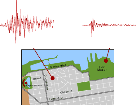
Location, location, location
This map of San Francisco's Marina district
shows two sesimograms recorded during an aftershock of the 1989 Loma Preita
earthquake in northern California. The seismograms were taken at the same
time in locations less than 1100 feet from each other. One location is
on solid bedrock, the other is on landfill. Which is which?
Click your "back" button to return to the previous page. |
|
|
Live Eye • Great Shakes • Quake Basics • Damage Control • Active Zone