|
||||||||||||||||
|
|

|
||
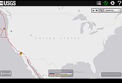
| Ever hear about a big temblor in North Dakota? Probably not. There have been virtually no sizable earthquakes in North Dakota during modern history. Just 1200 miles away, in central California, there's a minor shaker every few weeks. A quick glance at a map of recent earthquake activity in the United States will almost always show a cluster of activity in the western part of the country and very little elsewhere. The same is true for other regions of the globe—some, like Central Asia, have lots of earthquakes. Others, like Australia, have almost none. Why do some people have all the fun? |
|
|
|
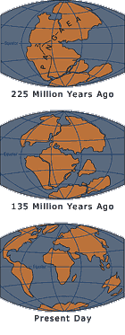
The answer is that some places on the earth's surface are, literally, on the edge. During its early years, the earth's outer layer was much hotter than it is today. Over time, the surface of the earth cooled and hardened. Cracks formed in the hardened surface, creating huge plates of rock. These plates carry the continents and make up the ocean floor, floating like islands on the hot, taffylike rock below. Where the edges of those plates meet, the huge slabs bash into each other, grinding, rumpling, scraping, and generally shoving each other around. We experience the more dramatic of these encounters as earthquakes. These collisions are more than just momentary shake-ups. They are the forces that shape mountains, create volcanoes, and generally affect what the map of the earth looks like. In fact, look at a map and you can see evidence of how the continents have moved around. It's not a coincidence that South America and Africa look like puzzle pieces that could fit together. They, like all the other continents, were once stuck together in a giant supercontinent that scientists call Pangaea. Over the last 200 million years, the continents have moved apart. While we think of their locations now as permanent, they are actually moving around very slowly, on average about 2 inches (5cm) a year. The theory that describes this movement is called plate tectonics. Plate tectonics is the outcome of thinking that began with an idea posed by German meteorologist Alfred Wegener in 1915. Wegener saw that the continents of the globe looked like a puzle that had broken apart, and he believed this was because they once been one large continent had split up. He gathered a great deal of evidence to support his theory of continental drift. But because he couldn't explain how the continents moved, most geologists at the time didn't agree with him. Twenty-five years after Wegener's death, scientists discovered a deep trench beneath the Atlantic Ocean where molten rock from inside the earth welled up and then cooled in the ocean waters, creating new rock. This led them to an observation: If the earth is creating new seafloor, old seafloor must be disappearing, or the earth would grow. So what's happening? The answer is that the new seafloor is being created at the edge of a tectonic plate. The plate's opposite edge is moving away from the new seafloor, diving under the plate it is bumping up against in a process called subduction. Researchers recognized this as an engine that could move continents, and realized in the 1960s that Wegener had been right all along. Most seismic action arises not from diverging plates, but from plates of the earth striking each other. These collisions create land features like mountains and volcanoes, and unleash the forces of earthquakes and tsunamis. Plates that grind past each other can also unleash powerful earthquakes, like the one that occured in San Francisco in 1906. The outcome of these bumps and grinds depends on the angles at which the plates meet and which directions they're moving. These factors characterize the action at a fault zone . |
||
Live Eye • Great Shakes • Quake Basics • Damage Control • Active Zone


