Dispatches from the La
Ni
ñ
a
Summit
Mary K. Miller
July 15, 1998
Boulder, CO.
|
|
The thing that really strikes
home to me after the first day of the La Niña Summit is that
weather really is a global phenomenon. If you listened to the webcast
(or the archive), you heard a diversity of voices from four continents
and two hemispheres. I chatted with scientists from Ethiopia, Argentina,
Australia, Kenya, Uruguay, China, Canada, and Japan. There was even
a meteorologist from Cuba. It's not just that all these nations experience
weather of some kind, but that much of the world is affected by the
same conditions that start in the tropical Pacific. Last year, a pool
of warm water and slack trade winds shifted the winter storm tracks
and concentrated rain in California, leaving northern states warmer
and drier. There were clear winners and losers from El Niño
last year: Argentina suffered major flooding, home and crop losses;
Canadian wheat farmers enjoyed a bountiful winter harvest; Indonesia
experienced drought and devastating fires; Florida and Cuba had no
hurricane season to speak of. It was impossible for scientists to
keep from talking about good old El Niño, although they were
gathered to talk about the new weather kid on the block: La Ni
ñ
a.
|
|
This conference
was organized by Michael Glantz, a social scientist at the National
Center for Atmospheric Resesarch, to try and come to some scientific
agreement about what La Niña is, whether we'll be affected
by it this winter, what the regional impacts will be, and how much
uncertainty remains. Most scientists at the conference agree that
La Niña is indeed coming. She begins when cold water spreads
eastward across the tropical Pacific and replaces the warm water at
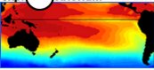
the surface. Michael McPhaden from NOAA monitors an array of buoys
in the Pacific and reported that the water temperature drop has been
dramatic: 13 degrees Fahrenheit in 20 days. He said the pool of cooler
water is large and likely to stay around for awhile. Cooler water
inhibits storm formation, so the Eastern Pacific off the coast of
South America and up into Southern California is likely to be drier
next winter--the same places that were socked by El Niño last
year. At the same time, more storms will develop in the western Pacific,
where warmer-than-normal water helps feed tropical storms. These storms
soak nearby Indonesia and New Guinea, then follow a track with the
jet stream into the Pacific Northwest and across Canada and the northern
United States. The regions that were dry last year can expect a good
dose of rain and cooler temperatures this year.
|
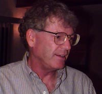
Michael Glantz, a social scientist at NCAR (and Milton Berle's
nephew) organized the La Ni
ñ
a
Summit.
|
|
|
People sometimes
describe these alternating tropical condtions, collectively known
as El Niño/Southern Oscillation (or ENSO), as a pendulum, but
it's not a simple pendulum. Sometimes La Niña comes on the
heels of El Niño, sometimes not. It's more like a chaotic pendulum;
so far the climate modelers can't predict which way or how far it
will swing. In the last 20 years, there have been three El Niño's
and two La Niñas. It's not uncommon for La Niña to come
after El Niño, but to have such extreme temperature swings
in the ocean is unusual.
|
There is a lot of talk at the Summit about what's normal for weather,
and agreement that it's normal to get extreme weather even when we're
not in an El Niño or La Niña year. But warmer or cooler
water in the tropical Pacific "loads the climate dice," as Tim Barnett
from Scripps Institute of Oceanography phrases it. That means if you're
trying to plan for water resources, energy demand, crop yields, or
weather damage, you're wise to take into account what's happening
with ENSO. That's one reason why scientists from universities and
NOAA reported a developing La Niña months ago. Jim O'Brien,
from Florida State University, considers it a public service to warn
people that "the girl" is coming, especially since his state
is much more likely to get pounded by hurricanes this season than
it was last year. Back in the 1970s, O'Brien was one of the first
oceanographers to reconize El Niño as a weather disrupter,
and he reminds people of the importance of the tropical Pacific: "It's
the ocean, baby!"
|
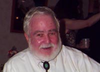
Jim O'Brien, from the Center for Ocean-Atmospheric Prediction
Studies at Florida State University.
|
|
Return to the
La Nina Summit WebCast
/ ©1998
The
Exploratorium
|