|
Background
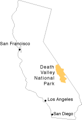
Death Valley is located in southeastern California. It
is just east of the Sierra Nevada mountain range. These mountains to the
west squeeze out most of the moisture from Pacific storms, leaving Death
Valley in the "rain shadow" receiving an average 1.5 inches of
precipitation per year. Due to extremely high temperatures; 120 degrees
Fahrenheit is a fairly common summertime temperature; the rain that does
fall is subject to an evaporation rate of 150 inches a year. In driving
east toward Death Valley in winter, one can see vegetation gradually change
from lush green grass on the western slope of the Sierra Nevada to more
sparse and hearty brown brush and scrub. There are four major ranges one
must cross when traveling from the west: the Sierra Nevada, the Inyo, the
Argus, and the Panamint.
|
|
Death Valley received its name from pioneer miners and settlers
who died or nearly died crossing the Valley on their way to the gold rush
of 1849. A reporter for the "New York World" fifty years later
called Death Valley, "the loneliest, the hottest, the most deadly and
dangerous spot in the United States." Perhaps because of its reputation,
as well as its barren and stark features, it took a while for Death Valley
to be recognized by the public and politicians as an important place worth
preserving. Just three and half years ago, on October 31, 1994, it was finally
promoted to National Park status, with the signing of the historic Desert
Protection Act.
|
|
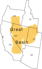
Death Valley is an enclosed basin--rain or water that flows
into the basin remains or evaporates. Death Valley forms the southwestern
portion of the Great Basin Desert. The Great Basin lives up to its name.
It contains nearly 1/4 million square miles covering most of Nevada and
portions of Oregon, Utah, and California. Death Valley is different than
the hundreds of other valleys in the basin because it's the lowest, hottest,
and driest location in the Western Hemisphere. Death Valley itself is 130
miles long and between six and thirteen miles wide. The valley is surround
by steep mountain ranges: the Panamint mountains to the west, and the Black,
Funeral, and Grapevine mountains to the east. Telescope Peak in the Panamint
range is the tallest peak in Death Valley National Park, topping 11,000
feet above sea level.
|
|
When you find yourself in a such a dry and barren place, it's
difficult to imagine that in the past Death Valley was largely covered with
water. Only 2,000 years ago, a 30-foot-deep lake filled part of the valley.
About 10,000 years ago there were several lakes, including one body of water
know as Lake Manly, which was nearly 600 feet deep! We know about the existence
of these lakes from the sediments that they left behind. Evaporation has
created a huge salt pan in the valley.
|
|
|
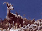
Death Valley is home to a variety of wildlife
including this bighorn sheep. Photo provided by the National Park Service.
|
|
|
|