| Sausalito's Bay Model Goes with the Flow (Continued) | |
|
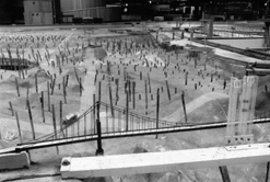
The Bay Model, constructed by the U.S. Army Corps of Engineers, was built in 1956 to help Army engineers evaluate plans for barriers that were proposed to create freshwater reservoirs within the bay. Although this ambitious plan was abandoned, the facility was retained and has remained a useful tool for the past forty years. |
|
|
Scientists subsequently used the model to determine how tidal circulation patterns affect water quality and how reclamation of bay shoreline land and navigation channel dredging would affect the bay. Since the model was expanded in 1966 to include the Sacramento-San Joaquin Delta, studies have also been conducted to evaluate changes in salinity (the proportion of salt in water) and to determine the effects of breakwaters, water discharge, and sediment disposal on currents and the bay and river ecosystem.
|
Listen to Ron McDonald Park Ranger and Educational Coordinator of the Bay Model. 28.8 Version Listen to David Fry , director of the Bay Model's Hydraulics Laboratory. 28.8 Version |
|
Several similar facilities have been built through the years, but the Bay Model is unique because of its longevity, due in part to an ingenious system of 286 concrete slabs individually supported on adjustable jacks. Most tidal models are used for only a few years because as the ground under the model shifts and settles, the model's layout is no longer an accurate representation of the estuary's topography. The Bay Model, however, is recalibrated to reflect such changes by adjusting the appropriate jacks. In addition to the model, the visitor center features exhibits and displays about San Francisco Bay's natural history and human impacts on the region. The highlight on the model's sidelines is the Marinship exhibit, which features graphics and artifacts that tell the story of the World War II shipyard that predates the model. The exhibition chronicles how thousands of ship workers and support personnel, living and working in a self-contained community, built dozens of ships at this site for the war effort. The center also offers walking and historic vessel tours, art and photography exhibitions, holiday events, and other events for the public, as well as teacher workshops. The model is being upgraded this fall and will not be used for experiments until 1997, but the visitor center is open Tuesday through Sunday, 9 a.m.-4 p.m. Call ahead at (415) 332-3871 to find out when the model will be in operation. Special technical tours can be arranged for engineering and other scientific groups by calling (415) 332-5485. |
|
Related Sites:
Bay Area Model:
Information on the Bay
Model, provided by the Center for Land Use Interpretation (CLUI).
|
|
|
|
|
|
|
|