|
|
|

|
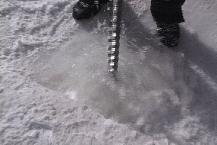
Using
an ice auger to drill into sea ice to measure thickness.
|
|
|
(Click
for a larger image)
|
|
Lessons on Sea Ice,
p2
|
|
|
by
Mary K. Miller
The
best way to avoid such mishaps is to drill down into the ice
until you hit water and to measure the thickness. Depending
on its weight, each vehicle needs a certain thickness of ice
to safely drive over. With our classroom lesson over, we hopped
in a big track vehicle called a Nodwell (this one was named
"Uncle Buck.") and drove out of town. After a few
miles of deafening, bone-chattering transport in Uncle Buck,
we stopped for a hands-on lesson in measuring the thickness
of sea ice using a hand-cranked auger. It takes several minutes
to finish the drilling before we found out that the sea ice
is over 3 meters (9 feet) thick, plenty thick enough for Uncle
Buck to drive over.
It
turns out that the sea ice is thicker over McMurdo Sound this
year than in recent history. The reason lies in an event that
happened in March 2000. That’s when a huge iceberg, named
B-15, broke off the Ross Ice Shelf 200 miles east of McMurdo
station When it calved off, B-15 was the size of Jamaica and
extended 900 feet below the surface. . Why it broke off is
still under debate but some scientists think that it may be
related to global warming.
Whatever
the mechanism, B-15 is one of the largest icebergs in recorded
history and it soon went floating toward McMurdo. The giant
berg eventually crashed into Ross Island not far from McMurdo
Station. The berg is so massive that it blocked currents moving
into the sound, turning the sea into what Ted described as
a giant millpond. Ice started forming behind B-15, covering
the sea from Ross Island to the Drygalski Ice Tongue to the
east.
The
sea ice grew so thick that it never melted last summer around
McMurdo Sound and it looks like it’s also here to stay
this year. That’s great for vehicles and people to travel
over the ice, but not so good for the wildlife. For instance,
Adelie penguins normally breed and raise chicks in rookeries
along what would be a coastline in the summer. The Adelies
depend on getting into the water to fish and feed their young.
The ice edge is now 73 miles away, a long walk for a penguin.
By the time they arrived this year from the open sea to the
rookeries, usually sometime in November, they were already
exhausted. It shows: from some early surveys this year, scientists
have seen a dramatic decline in the numbers of breeding penguins.
We’ll be going out to take a look at an Adelie rookery
for ourselves later this month.
The
U.S. Coast Guard will also have to contend with the ice in
late December. That’s when a couple of icebreakers will
cut a channel in the ice to clear the way for Greenwave, the
huge ship that carries all the supplies for McMurdo station
for the next year. Normally the Coast Guard only needs one
icebreaker but with 73 miles of ice to cut through, they’re
bringing out two this year. People have been laying odds on
how long it will take them to get through to McMurdo, always
a big event here on the station.
links:
Ice
Gallery
(requires
Flash
5 player
).
Satellite
images of icebergs and sea ice:
1
,
2
Iceberg
Movies
|