Step 3: Confirm data using a buoy.
|
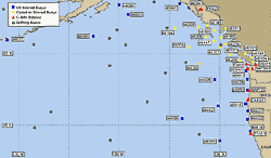
| Click on the image to see its actual size. |
When we click on our selected region, we get a close-up map of the area with symbols indicating buoys. Here's where latitude and longitude information comes in handy: Use it to locate the buoy nearest the high winds that are directed toward your beach. There aren't as many buoys in the open ocean as there are along the coasts, so you might not be able to find one near your storm. But if you can, it's worth using the data available there to confirm what you see on the wave model diagram.
Remember, we estimated the location of our storm at 45N latitude and 165W longitude, and the highest winds blowing toward our beach are a bit south and west of there. From the map, it looks like the nearest buoy to those high winds is 46701, a drifting buoy. You can click any of the buoy symbols on this map, and you'll reach a page with with information about conditions near that buoy. When we looked at our page for buoy 46701, we saw that the buoy was located at about 37N and 160W. The wind speed was 36.1 knots, or over 40 miles per hour. That's some wind! You can convert knots to miles or kilometers per hour by using this page: http://www.convert-me.com/en/convert/speed .
So, we've figured out the first step: We've got a storm that's blowing some decent winds across a relatively large area of ocean. Will it bless our Santa Cruz beach with nice surfing swells? And if so, when? A few more pretty diagrams from NOAA will help us figure that out.
|
|