Step 1: Find a storm headed your way.
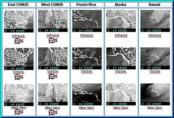
Storms equal wind which equals waves. Weather travels from west to east, so we want to find a storm west of our Santa Cruz beach. We'll start with a satellite photo, the kind you see weather forecasters standing in front of on the nightly news. NOAA's Geostationary Operational Environmental Satellite (GOES) page has images of the U.S. coasts, Puerto Rico, Hawaii and Alaska. If you live in another country, you can find a satellite image on the University of Wisconsin's Space Science and Engineering Center's GOES satellite page . You can use these images to see most of the world.
 Our
example begins on February 6, 2003. Going to the NOAA GOES page, we find
rows of satellite pictures. Look at the want the pictures in the second
row, in the visible spectrum. The second picture from the left shows the
West Coast and the open ocean next to it. That's our photo!
Our
example begins on February 6, 2003. Going to the NOAA GOES page, we find
rows of satellite pictures. Look at the want the pictures in the second
row, in the visible spectrum. The second picture from the left shows the
West Coast and the open ocean next to it. That's our photo!
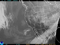
We get a larger live satellite image by clicking on the small one in the grid. In it, you can see a storm to the west, just at the edge of the frame.
|
| Click the picture to see it actual-size version. |
|
|