Step 2: Check the winds.
Our next important task is to determine whether that cloud cover we see to the west of the California coast is the sort of storm that will bring good waves (to learn more about how storms create waves, see the "Making Waves" article ). One of the most important determining factors is the wind—its speed, direction, and the area over which it's blowing. NOAA's Wavewatch site maintains a on-line database of images reflecting wind speeds, wave heights, and other conditions, updated every six hours. At first, it looks a bit confusing to navigate. But don't be deterred—it’s really quite simple, and you’ll be amazed at the things you can learn about the weather!
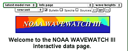 Here's
what the page looks like when you arrive (it may take a few seconds
to load, so be patient). You’ll see menus on the top that you
can use to find the most current images of wind speeds headed toward
your beach (and to find other things later).
Here's
what the page looks like when you arrive (it may take a few seconds
to load, so be patient). You’ll see menus on the top that you
can use to find the most current images of wind speeds headed toward
your beach (and to find other things later).
|
|
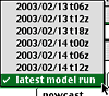 Begin
by selecting the most recent information. The first menu says "latest
model run," and that’s the one you want. NOAA runs the models
every six hours, and if you click on the menu, you’ll see that
you have the option of seeing any of the last six runs. But for forecasting
purposes, the latest run is the best choice.
Begin
by selecting the most recent information. The first menu says "latest
model run," and that’s the one you want. NOAA runs the models
every six hours, and if you click on the menu, you’ll see that
you have the option of seeing any of the last six runs. But for forecasting
purposes, the latest run is the best choice.
|
|
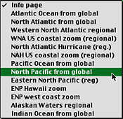 Next,
you want the run from the area where your beach is located. NOAA gets
information from all over the globe; it’s a matter of finding
which view shows conditions heading toward your beach. For this example,
we’ve chosen "North Pacific from global" because that’s
the view that gives us the California coast. If you’re in Australia,
you’ll want to look at "Pacific Ocean from global."
On the East Coast of the U.S., you'll want "North Atlantic from
global," etc.
Next,
you want the run from the area where your beach is located. NOAA gets
information from all over the globe; it’s a matter of finding
which view shows conditions heading toward your beach. For this example,
we’ve chosen "North Pacific from global" because that’s
the view that gives us the California coast. If you’re in Australia,
you’ll want to look at "Pacific Ocean from global."
On the East Coast of the U.S., you'll want "North Atlantic from
global," etc.
|
|
|
|
|
|
Okay, now you’re set! Click the "go" button and wait. These images can take a while to get, so be patient.
|
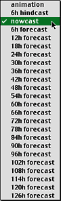 Just
below the model run menu is the forecast menu. Here, you select
which forecast you want. NOAA offers forecasts for several days
into the future, as well as a "hindcast," a "nowcast,"
and an animation. The "nowcast" is an image of the conditions
that existed during the last run. We’ll use that, since it’s
a record of what’s actually happened, though the shortest-term
forecast is also likely to be accurate.
Just
below the model run menu is the forecast menu. Here, you select
which forecast you want. NOAA offers forecasts for several days
into the future, as well as a "hindcast," a "nowcast,"
and an animation. The "nowcast" is an image of the conditions
that existed during the last run. We’ll use that, since it’s
a record of what’s actually happened, though the shortest-term
forecast is also likely to be accurate.