Step 2: Check the winds (continued):
|
|
|
|
Click the image to see a larger, more detailed version.
Print
out our other wave models:
|
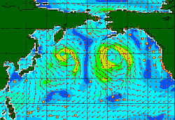
Voila! This image is the reward for your patience. Just a quick glance and you'll see that there are fairly strong winds blowing, and luckily, some of them are directed toward the northern California coast. Click the image to see the larger, more detailed version.
When you're looking at your storm on the wave model image, note its latitude and longitude. For example, on the large version of the February 6 image, you can see that the storm is centered close to 45N latitude and 165W longitude, and that the strongest winds are blowing around that center. You won't be able to be exact with your latitude and longitude coordinates, but even an estimate of the numbers will be useful in locating and calculating other information.
You might want to write down your latitude and longitude, so that you're sure you're using the same numbers throughout your calculations. You might also find it helpful to print out your wind speed image and mark the spot you've chosen. Now you're ready for the next step.
|
|
|