Zambian Geography Dispatches A Glimpse of Zambia Zambian Geography Zambian Wildlife STEREO Mission International Space Station
Click for Webcast

Zambia, Lay of the Land
Map of Zambia
Roll your mouse over the geographic features on the map for descriptions.
Lake Tanganyika Copperbelt Zambezi River Victoria Falls Lake Kariba Lusaka/Web Crew Location in Lower Zambezi


map of Africa
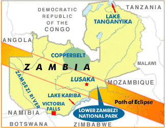
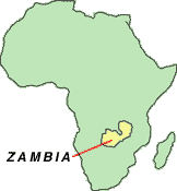
Zambia sits atop the southern African plateau, nestled within the borders of eight countries. Slightly larger than Texas, the country covers nearly 300,000 square miles. It’s cooler than most tropical countries, thanks to the altitude of the plateau, which approaches 5,000 feet in the east. Elevations gradually drop as the terrain descends into the wide valleys and floodplains to the west and south.  

QUICK FACTS

Population: 9,582,418
Area: 290,586 sq. mi.
Currency: Kwacha
Government: Republic
Capital: Lusaka

Zambian Flag
ZAMBIAN FLAG

eagle and red = freedom
black
= people
orange = mineral wealth
green = natural resources
Named after the imposing Zambezi River, Zambia boasts vast stretches of wilderness and spectacular natural formations. Grassy plains dotted with thick forests blanket much of the land, but Zambia’s most dramatic sights adorn its edges, from the mammoth Lake Tanganyika in the northeast to the dazzling Victoria Falls in the south.

Victoria Falls

Click here to see some of the wildlife found in Zambia's national parks.

Eclipse 2001 : DISPATCHES | GLIMPSE OF ZAMBIA | GEOGRAPHY | WILDLIFE | STEREO MISSION | INT'L SPACE STATION

Back to Solar Eclipse: Stories from the Path of Totality

©2001 - Exploratorium