|
September
15, 2004
The science of this workshop is focused around the climate
phenomenon known as El Niño, or more formally ENSO
(El Niño Southern Oscillation). We heard from climate
forecaster Tony Barnston of Columbia University’s International
Research Institute (
http://iri.columbia.edu/
)
about the latest in El Niño forecasting and climate
prediction (NOTE: the audio stream for this session is not
available).
The biggest
news is that earlier in September, NOAA (
http://www.noaanews.noaa.gov/stories2004/s2317.htm
)
announced that a “weak” El Niño has developed
in the east-central tropical Pacific (
http://iri.columbia.edu/climate/ENSO/currentinfo/update.html
).
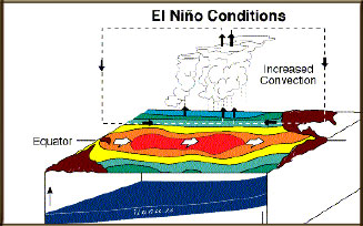
When climate scientists say weak, they mean that the warming
of sea surface temperature that characterizes El Niño
is relatively small. For this current El Niño, the
ocean temperature is an average of 1 degree Centigrade above
normal just to the east of the dateline in the tropical Pacific.
As this warmer water on the sea surface spreads eastward toward
South America, it can impact weather in the U.S. and around
the globe, creating wetter-than-normal or drier-than-normal
conditions (in California, we get higher rainfall in the winter
during El Niño years).
Predicting El Niño
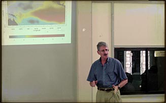
This is a late-developing El Niño, Tony Barnston says,
and took many of us by surprise. Usually they pop up in late
spring and may persist for about a year. “My confession
is that we’re not good at predicting the onset of El
Niño but we’re pretty good at knowing about how
long they will last once they get started,” he says.
That’s fine for the U.S., which usually feels the impact
of El Niño six months after it develops. “But
people in India, Australia, and Africa’s Sahel desert
probably think we’re dumb because they start experiencing
impacts much earlier, from June through August, just as the
El Niño usually begins, and have no time to prepare.”
Why is
El Niño so hard to predict? It comes down in part to
the difference between weather and climate, Barnston says.
When scientists say weather, they’re talking about the
short-term changes in the atmosphere that lead to rain, wind,
clouds, and changing temperature on a day-to-day basis. Climate
is the long-term or seasonal average of temperature and precipitation
that happens over months or years. “We’re good
at weather forecasting, there are computer models that provide
lots of details about storms, winds, fronts, and pressure
conditions out to about five days in the future.” Predicting
climate is another matter. Longer-term climate conditions
are subject to many factors working together, and the system
is very sensitive to initial conditions. That means that a
small change in atmospheric pressure, wind patterns, or ocean
temperatures and currents can have a large impact on weather
for any particular day in the future beyond the fifth day.
Still, knowing about likely changes in seasonal average temperature,
rain, or snow patterns is very useful for farmers, water and
utility companies, and folks thinking about repairing their
roofs. That makes scientists like Tony Barnston accountable
to people on the ground (or “users” in the vernacular
of this workshop), motivating many in the field to develop
more accurate climate forecast models and to make their results
more understandable and useful to the public.
Impacts
of El Niño
After getting a handle on what El Niño is, the rest the day
was spent talking about what El Niño does. Scientists estimate
that 25% of the earth’s land surface is affected by
El Niño in some way or another. Here is a sampling of some
of the impacts:
-
Increased cyclone activity in tropical Pacific Islands
-
Drought in parts of Australia affecting farming
-
Collapse in fisheries in eastern Pacific, off the coasts
of Peru and Ecuador
-
Micronesia has a combination of droughts and floods
-
Rice crop in the Philippines can see much lower yields
-
In flooded areas, health effects include more possibility
of mosquito-borne diseases, and lack of fresh crops affects
nutrition.
|