Step 5: When will the waves hit?
Another NOAA wave model and some calculations will help answer this question. Go back to the NOAA wave model Web page. This time, instead of wind speed or wave heights, choose the nowcast for wave period. Wave period is the time between wave peaks, and the longer the period, the faster the waves are moving. From this image and some other information we'll give you, you'll be able to determine how fast the waves are moving, how far they have to go, and finally, when they will reach you.
|
|
Click on the image to see its actual size.
Print
out our other wave models:
|
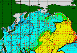
Again, it might be interesting for you to print out this image and compare it with the other two; You'll get a fuller impression of the many aspects of ocean conditions. Or you can just work from this one image. Looking at the wave periods associated with our storm in the north Pacific, it's no surprise that we find the fastest-moving waves (the ones with the longest period) where the strongest winds are blowing.
To figure out when the waves will reach us, we need to know two things: how fast they are moving, and how far away they are. Again, we'll use our latitude and longitude information. It looks like the wave period by our buoy at 37N and 160W is 13/second. (Have a look at the larger image and you'll see how we discerned this.)
Via a mysterious formula (it's not all that mysterious. If you're interested, download our explanation .), we've figured out that you can calculate the speed of the waves by dividing the wave period by .641. This gives us an answer in knots, or nautical miles per hour.
13 (wave period) ÷ .641 = 20.3 knots
And how far away are the waves? That's easy, we just need to find another buoy.
|
|