|
|
|
|
||||
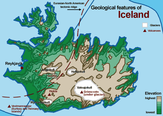
Tectonic Ridge: Iceland is the only place on Earth where the meeting of two tectonic plates occurs above sea level. This ridge is the source of the island's volcanic activity. Magma from the Earth's core pushes up through the area around the ridge, creating lava flows that continue to add to Iceland's landscape. Geysir: Located near the small town of Haukadalur, the "Great Geyser" used to regularly spout plumes of superheated water and steam as high as 60 to 80 meters. The English word "geyser" is derived from the Icelandic "geysir," which means "gusher." Though the Great Geysir is now relatively dormant, it sits amidst a geothermal park that resembles Yellowstone, with its hissing steam vents, belching mud pots and burbling springs. For more on Geysir, check out the South Iceland travel bureau's page at www.south.is/geysir.html . Grimsvotn: In 1998, this volcano erupted, spewing ash up through Vatnajokull glacier, miles into the sky. Grimsvotn is one of several unusual volcanoes in Iceland: rather than a mountainous cone, this volcano is actually a fissure hidden under a monstrous glacier. Other eruptions under the glacier have melted massive amounts of ice and resulted in floods and washed out roads and bridges. Hekla: The most prominent volcano in Iceland, Hekla is a large, elongated mountain cut through the middle by a 5.5 kilometer fissure. Lava and ash often flow along the entire length of the fissure during eruption. Ash and lava from eruptions as far back as 1104 can be found all across Iceland, which can be used to date eruptions around the island. Hekla's 1104 eruption was one of the largest in Iceland's history. Vestnannaeyjar: Two of this century's most notable eruptions have come from this chain of volcanic islands. In 1963, an eruption began from the ocean floor. By the time it stopped in 1967, a new island, which was named Surtsey, had formed off the southern coast of Iceland. Then, in 1973, a major eruption occured on the island of Heimaey. Spectacular curtains of fire and continuous lava fountains flowed for the first three days, and hundreds of homes were buried under ash and lava bombs. Inhabitants of the island fended of total destruction of Iceland's major port by dowsing the lava flows with cold water. For more on this major event in Iceland's recent history, see the USGS publication "Man Against Volcano."
|
|
|||||
|
copyright Exploratorium 2001 |
||||||