|
|
|
|
||||||||||
Perhaps the most striking geological feature of Iceland is its volcanoes. Pocked by more than two hundred volcanoes, Iceland is one of the world's most volcanically active regions, spewing a third of the earth's total lava flow over the past five hundred years ( our geological map tells you about some of the most active areas). Sitting Smack Dab on a Mid-Ocean Ridge Icelanders can thank their island's unique location for this intense volcanic activity. Slicing through the center of modern-day Iceland is a geological feature called a mid-ocean ridge. This is the boundary between two continental plates, which are the enormous slabs that make up the earth's crust. As these plates slowly move apart -- at a rate of about an inch each year -- fissures periodically form in the crust. Over time, these gaps allow molten rock from underground to surface as lava, creating Iceland's many volcanoes. There are many places on earth where two continental plates drift apart, but most of these sites are deep under water. Iceland is one of the few places in the world where such a boundary occurs above sea level, helping to explain the island's unusually active geology. Not only is the mid-ocean ridge responsible for building the volcanoes on Iceland, it's also the driving force behind the creation of the entire island. Beginning about seventy million years ago -- long after the earth's other continents had formed -- lava from volcanic eruptions along the mid-ocean ridge cooled as basalt (a dark rock) to make all of Iceland's present-day land surface. These ancient lava flows helped to shape the island's plateaus, mountains, and other topographical features. Today, in fact, a historical record of lava flows is visible in the parallel layers of basalt that line the sides of many of Iceland's glacier-cut valleys.
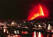
Documented history of Iceland's volcanic eruptions began in 874 A.D., when the Vikings first settled the island. Since that time, the island has had about 125 volcanic eruptions -- more than any other comparably sized region in the world. Some of these eruptions have led to famine, destroyed homes, and generally wreaked other havoc on human settlements. Most notably, Iceland is the site of the largest lava flow in recorded global history. In 1783, an eruption at a mountain called Laki tore a chain of giant craters in the earth. Besides releasing 2.9 cubic miles of lava and inundating 218 square miles of land, the craters also belched a haze of toxic particles into the air, which was reported as far away as Syria. The poisoned air devastated Iceland's livestock and farmland, contributing to a famine that killed about a quarter of the island's residents. About two hundred years later, in 1973, another destructive eruption occurred on the small island of Heimaey, several miles from mainland Iceland. The event, which lasted several months, destroyed about a third of the town of Vestmannaeyjar, the nation's premier fishing center. Authorities had to evacuate most of the town's residents, and spray seawater on the lava flows to halt their advance into the town.
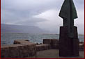
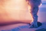
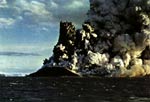
Many Icelandic eruptions have offered important scientific insights. Between 1963 and 1967, for instance, an underwater volcano twenty miles south of Iceland belched enough lava to form a new island, which Iceland named Surtsey. Since it's rare for volcanoes to make permanent new islands, Surtsey has offered an important opportunity for scientists to investigate this geological process. Surtsey has also been an invaluable laboratory for biologists to monitor the arrival of colonizing species to a barren new island. Averaging one eruption about every five years, Iceland certainly has an intimidating -- and sometimes destructive -- geology. But this geology is, arguably, more of an asset than a hazard. Volcanoes have sculpted Iceland's unique and beautiful landscape, which Icelanders and tourists alike savor. Many come to the island to see volcanic hot springs and geysers, and possibly even witness a fiery red river of lava from an erupting volcano. If you're planning a vacation in Iceland, you can bask in the island's geothermal pools and enjoy the scenery without fear. Because the island is so sparsely populated, the overall threat volcanoes pose to people is low: The majority of blasts have occurred far from human settlements. If you're a scientist, you can also find plenty of fascinating attractions. Researchers from around the world come to Iceland to study everything from ancient lava flows to the movement of continental plates. In fact, Iceland is a gift to science, offering glimpses of land-based geological processes not visible anywhere else on earth. Want to know more about Iceland's volcanoes? Here's a few links:
About
the 1998 Grimsvotn eruption
Man Against Volcano
Nordic
Volcanological Institute
|
|
|||||||||||
|
copyright Exploratorium 2001 |
||||||||||||